About
Mark van Tatenhove formed SAS Site Audits in 2025, after working on so many projects realising that the only way to provide a good design solution and define a project scope was to start with the right information.
Since 2025

Meet The Founder
Mark van Tatenhove
CEO
Founder and Entrepreneur, Mark has built a reputation throughout the industry, as someone that is innovative, as well as providing sound process management in delivering sound project solutions. Mark is Registered Project manager (CPPP) listed with the Australian Institute of Project Management
It’s about having clarity, and this begins at the very start of any project.
Professional Credentials
Mark has over 30 years experience in retail design & construction management, as well signage and commercial design development and installation. He started his career in retail designing fixtures & fittings for the Myer Department store development team before moving into project management and delivery. Mark has had extensive experience working with many brands, such as Country Road and Trenery, Coles Supermarkets, Kiehls etc, as well as Australia Post, Europcar and Multiplex working with internal and external stakeholders to deliver well designed solutions.

Clarity from Day One
The designer needs to see everything, where the walls are, the ceilings, any services that might impact the design such as drainage, electrical switch boards as well as what the flooring conditions are.
Once they understand this, plus have all the site dimensions they can effectively plan the space, and provide the right solution.

Advanced Technology
SAS Site Audits offer a range of services, from a 3D LiDAR Point cloud scan, BIM 3D Revit, and 2D AutoCAD drawings, to the hand measurement checks using laser measurers and digital photos and reports.
The 3D LiDAR scan is also great for doing walk throughs during the construction process, and for as-built verification.
Our Services
SAS Site audits provides 3 services – – Point cloud Scan to BIM (3D Revit and 2D AutoCAD drawings – Digital twins – capturing real information about the assets and – marked up drawings, showing you what the correct information is

Scan to BIM

Digital Twin

Marked Up Plans
Service
Scan to BIM
3D LiDAR point cloud scans
CAD conversions - 3D revit and 2 D autoCAD drawings
Accurate data for great plans
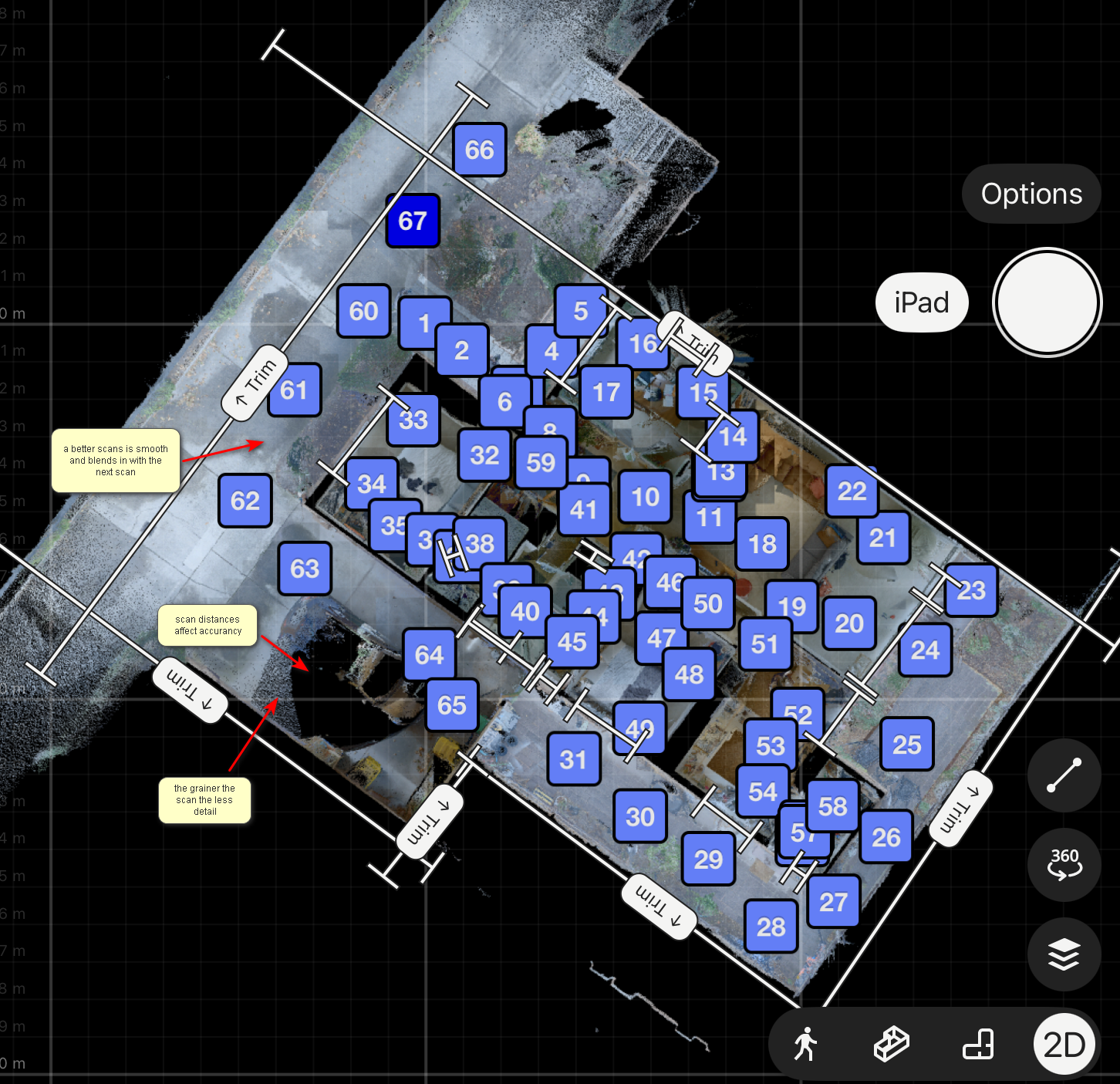


3D LiDAR Scan‑to‑BIM is a modern way to capture a building exactly as it exists today and turn that information into an accurate digital model. Instead of relying on old drawings, tape measures, or guesswork, SAS Site Audits use laser scanning technology to create a precise picture of the real world — and then converts it into a smart 3D model that designers, builders, and owners can actually use. From the raw scan with the help of a conversion file, the noise is removed a Building Information Model (BIM) is created. This isn’t just a 3D picture — it’s a digital version of the building with real‑world dimensions and information attached to every element. And its editable, making it perfect for ongoing changes in the future
Service
Digital Twin
digital replica of site asset
walk through of the site
asset information


A digital twin is a virtual replica of the space or building. It looks like the physical space, but more importantly, it brings together all the information that keeps that space running. Think of it as a smart, interactive dashboard for your entire store environment. Commercial spaces are constantly changing: new layouts, equipment upgrades, and ongoing maintenance. But the information behind those changes often lives in different systems, spreadsheets, or people’s heads. A digital twin pulls everything together so that operations, facilities teams, and leadership can see the full picture in one place. Digital twins give commercial operators a practical way to stay ahead — turning site data into real operational improvements. They help teams make better decisions, reduce waste, and keep their sites running at their best, day after day.
Service
Marked up plans and photo images
Confirmation of site measurements
Marked up drawings of client supplied plans and photos of existing conditions and any other notes


Existing client supplied plans marked up to show existing conditions – dimensions, floor to ceiling heights location of services, heights of walls etc. Hand measurements using laser measurement equipment Photo reference plan and digital photos of existing conditions